What Is an Orthomosaic Map? A Plain-English Guide for Land Buyers
Orthomosaic maps get explained for surveyors and drone pilots — rarely for the person actually buying the land. Here's what one is, what you can measure on it, what it costs, and where its limits are.
AD
Adam Dankhazi
Founder & Chief Remote Pilot
An orthomosaic map is a single, high-resolution aerial image of a piece of land, built by stitching together hundreds of overlapping drone photos that have each been geometrically corrected so the finished map is true to scale. Because every pixel sits in its correct position on the ground, you can measure real-world distances, areas and boundaries directly on the image — something you can't reliably do on an ordinary photograph or a satellite view. Think of it as a photographic map: it looks like a photo, but it behaves like a map.
That's the short answer. The rest of this guide explains how orthomosaics are made, what they can and can't tell you, what one costs, and — because we'd rather be honest than impressive — exactly where an orthomosaic stops and a licensed land surveyor begins. We write this from experience: land photography and orthomosaic mapping is one of the most-requested jobs we fly across Cyprus, usually for people deciding whether to buy a plot they've never stood on.
What is an orthomosaic map?
Break the word apart and it explains itself. Ortho comes from the Greek for "straight" or "correct" — as in orthodontics, which straightens teeth. Mosaic means an image assembled from many small pieces. An orthomosaic, then, is a mosaic of aerial photographs that has been straightened: corrected for camera tilt, lens distortion and terrain height so that the whole image looks straight down at every point, at a uniform scale.
Why does that matter? Take one ordinary drone photo of a two-acre plot and the centre of the frame looks straight down, but the edges lean. A tree at the corner of the plot appears to tip outward; a slope stretches or compresses distances. Measure across that photo and you'll be wrong — sometimes by metres. An orthomosaic removes those errors. It's the same trick professional aerial mapping and national cadastral agencies have used for decades, now achievable with a drone at a fraction of the cost and at far higher resolution.
The result, for a land buyer, is the single most information-dense document you can get about a plot short of walking it: every wall, track, olive tree, ruin, fly-tipped pile and encroaching fence, visible in one honest, measurable picture — taken this week, not whenever a satellite last passed over.
How is an orthomosaic made?
The process has four stages, and understanding them explains both why orthomosaics are so useful and why they take a couple of days to deliver.
Grid flight. The drone flies an automated lawnmower pattern over the plot at a fixed altitude, camera pointing straight down, taking a photo every couple of seconds. A typical building plot takes 200–400 photos.
Overlap. Each photo overlaps its neighbours by roughly 70–80%. That redundancy is deliberate: every point on the ground appears in many photos from slightly different angles, which is what lets software work out the terrain's true shape.
Stitching. Photogrammetry software finds millions of matching points across the overlapping images and knits them into one seamless image — the "mosaic" half of the name.
Geometric correction. Using the drone's GPS data and the 3D surface model computed from the overlaps, the software reprojects every pixel to its correct map position — the "ortho" half. This step is what turns a pretty picture into something you can measure.
The same flight also yields the plot's elevation data as a by-product, which is why contour lines and slope analysis usually come bundled with an orthomosaic rather than costing extra flights. When we fly a grid over a sloped parcel outside Paphos, that overlap is what lets us hand back an accurate contour map from the very same photos — no second trip up the hill.
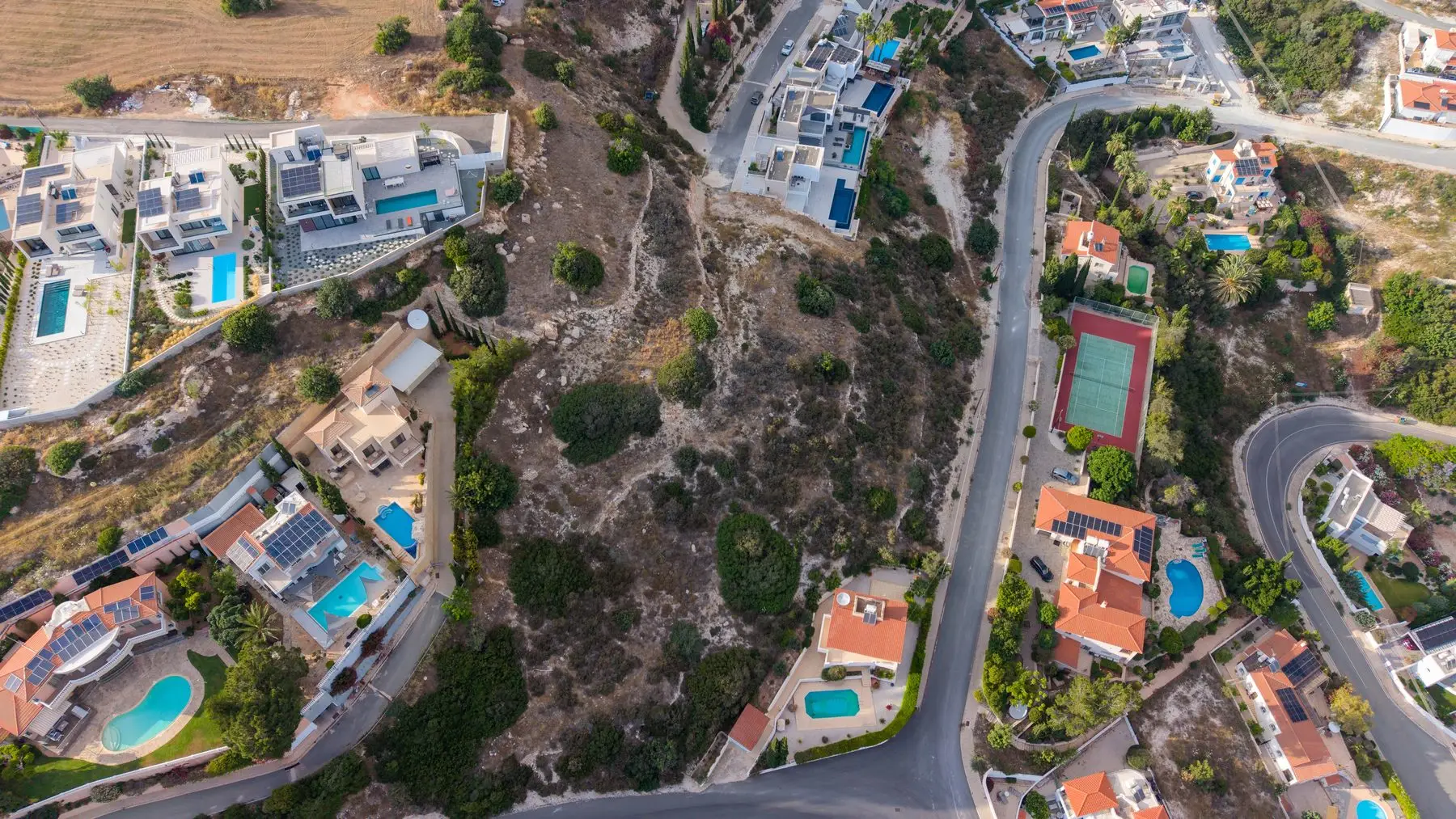
One frame from a mapping flight. The finished orthomosaic combines hundreds of these into a single corrected, measurable image.
Orthophoto vs orthomosaic vs photogrammetry vs satellite imagery
These four terms get tangled together constantly, including by people selling the services. Here's the untangled version:
Term
What it actually is
Typical detail
Best for
Orthophoto
A single aerial photo that has been geometrically corrected to a uniform scale
Depends on the source photo
Small areas covered by one frame
Orthomosaic
Many orthophotos stitched into one seamless, measurable map
1–3 cm per pixel from a drone
Whole plots and sites; measuring distances, areas and boundaries
Photogrammetry
The measurement technique behind both — extracting 3D geometry from overlapping photos
Produces orthomosaics, 3D models and point clouds
The method, not a deliverable; you order its outputs
Satellite imagery
Imagery captured from orbit (Google Earth and similar)
30–50 cm per pixel or coarser, often years old
Free context and rough orientation, not measurement
The one-line summary: photogrammetry is the method, an orthophoto is a single corrected image, an orthomosaic is the finished measurable map, and satellite imagery is the free but coarse and outdated alternative. When people search for "photogrammetry vs orthomosaic" they're usually comparing a technique with one of its own products — which is why the answers they find are so confusing.
What can you measure on an orthomosaic?
This is where an orthomosaic earns its keep. Because the image is scaled and positioned, you can take real measurements from your desk:
Distances. Frontage onto a road, distance from a boundary to a neighbouring building, length of a retaining wall — measured to within a few centimetres, without a tape measure or a flight to Cyprus.
Areas. The plot's usable area, the footprint of an existing structure, how much of the land is taken up by rock outcrop or mature trees. For buyers comparing plots, measured area beats advertised area surprisingly often.
Boundaries. A boundary overlay places the registered plot outline from the land registry on top of the photographic map. This is often the single most revealing deliverable: it shows at a glance whether the fence, the track or the neighbour's shed sits where the paperwork says it should. In our work mapping plots across Cyprus, the overlay is the moment buyers most often go quiet — it's not unusual for a fence to sit well inside the registered line, and seeing it on a scaled map lands very differently from being told about it. (Indicatively — more on that below.)
Elevation and contours. Because the mapping flight computes a 3D surface, sloped plots — most of Cyprus, in our experience — come with contour lines and elevation profiles. That tells you where the buildable flat area actually is and how much retaining or excavation a build might need.
The number that governs all of this is GSD — ground sample distance — the real-world size of one pixel on the ground, expressed in centimetres per pixel. A drone orthomosaic flown at typical mapping altitude achieves a GSD of 1–3 cm/pixel: one pixel covers a patch of ground the size of a coin. Google Earth, by comparison, is usually 30–50 cm/pixel — one pixel covers a patch the size of a chair. GSD is the honest spec to ask any provider for; if they can't tell you, ask someone else. Every orthomosaic we deliver is flown to land at the 1–3 cm/pixel end of that range, because anything coarser and the measurements a buyer actually cares about start to soften.
Who actually uses orthomosaic maps?
Land buyers — especially remote and overseas buyers — checking a plot's condition, access, slopes and boundary reality before committing. This is who we fly for most, and it pairs naturally with a wider drone survey of the site.
Developers planning layouts, cut-and-fill and access on raw land before engaging engineers.
Estate agents who want listings that answer buyers' questions instead of provoking them.
Construction teams tracking progress, stockpiles and site logistics month by month with comparable, measurable snapshots.
Agriculture — orchard and vineyard owners counting trees, assessing irrigation coverage and monitoring crop health across large parcels.
An orthomosaic tells you what's on the ground. Only a licensed surveyor can tell you what you legally own. Any provider who blurs that line is selling you a problem.
— our rule, stated up front on every mapping job
What does orthomosaic mapping cost?
In the US and UK markets, a standalone drone orthomosaic of a small site typically runs from around $300 for a basic map of a single plot to well over $1,000 once larger areas, ground control points or survey-adjacent accuracy enter the picture. Pricing scales mostly with area, required accuracy and processing depth — the flight is rarely the expensive part; the processing and the deliverables are.
Our own pricing in Cyprus is simpler. Orthomosaic mapping is an add-on to any of our land photography packages at a launch price of +€299 (standard price €599). The underlying packages start at €149 for the Basic (10 edited photos of the plot) and €249 for the Standard (20 photos plus a video flyover). The orthomosaic add-on includes the measurable map itself, a boundary overlay, area and distance measurements, and elevation and contour data for sloped plots. Everything is delivered within 48–72 hours of the flight, flown by licensed pilots, anywhere in Cyprus.
If you're weighing up whether you need the full add-on or just good aerial photos, the deciding question is usually: do you need to measure anything? If yes — boundaries, buildable area, slope — get the orthomosaic. If you just need to see the plot honestly, the photo packages alone cover it. The question we get asked most by remote buyers is whether the add-on is worth it sight unseen; in our experience, if there's any doubt about a plot's slope or where its fence really sits, it pays for itself the first time it changes your mind about a purchase.
— CyprusDroneX · Land & orthomosaic mapping
Need a to-scale map of your plot?
We fly, stitch and deliver orthomosaic maps of land across Cyprus — boundary overlay, measurements and elevation, from €299 as an add-on.
Limitations — when you need a licensed surveyor instead
Here's the section most articles about orthomosaics skip, and it's the one that matters most if you're buying land.
An orthomosaic is visual and indicative, not legally binding. The boundary overlay we deliver shows where the registered plot outline falls on the photograph to within the accuracy of GPS and the registry data — close enough to reveal that a fence is several metres inside your line, not close enough to certify exactly where that line is. In Cyprus, as in most countries, only a licensed land surveyor can legally demarcate a boundary, and only the Department of Lands and Surveys' records define what you own. If you're heading into a purchase dispute, a court case or a party-wall disagreement, you need the surveyor. No drone deliverable substitutes for that, whatever anyone selling one implies.
A few other honest limits: orthomosaics show the surface, so dense tree cover hides the ground beneath it; absolute GPS accuracy without ground control points is around a metre, which is fine for planning and useless for pegging corners; and a map is a snapshot — a plot can be cleared, fly-tipped on or fenced differently a month later. Cyprus adds its own layer of complications for buyers, which we've written about separately in our guide to the problems nobody warns you about when buying property in Cyprus.
Used the right way round, though, the two services compound: the orthomosaic is the cheap, fast early check that tells you whether something looks wrong, and the surveyor is the legal instrument you bring in once you know where to point them. Buyers who order the map first tend to spend their surveyor budget far more precisely.
The short version
An orthomosaic map is hundreds of overlapping drone photos corrected and stitched into one true-to-scale image you can measure — distances, areas, boundaries and elevation — at 1–3 cm per pixel, versus Google Earth's 30–50 cm. It's the fastest honest picture of a plot money can buy, delivered in 48–72 hours as a +€299 add-on to our land packages. It is indicative, not legal: for binding boundaries you still need a licensed surveyor.
Frequently asked questions
How accurate is an orthomosaic?
A typical drone orthomosaic resolves 1–3 cm per pixel, and measurements taken within the map are usually accurate to within a few centimetres relative to each other. Absolute positioning — where the map sits on the Earth — depends on the drone's GPS and is normally within about a metre unless ground control points are used. That's excellent for planning and comparison, but it is not survey-grade accuracy.
Can I use an orthomosaic in a legal boundary dispute?
No. An orthomosaic is visual and indicative — it shows what is physically on the ground, not what you legally own. Legal boundaries in Cyprus and most countries are defined by cadastral records and can only be certified by a licensed land surveyor. An orthomosaic is still useful evidence for spotting a potential problem early, but the surveyor's plan is what counts in a dispute.
How long does it take to get an orthomosaic map?
The flight itself usually takes under an hour for a typical building plot. Processing the hundreds of photos into a finished map takes longer — we deliver the complete package, including the orthomosaic, measurements and boundary overlay, within 48–72 hours of the flight.
What's the difference between an orthomosaic and Google Earth?
Three things: resolution, freshness and measurability. Google Earth imagery is typically 30–50 cm per pixel and can be years old; a drone orthomosaic is 1–3 cm per pixel and flown on the day you order it. And because an orthomosaic is geometrically corrected and scaled, you can take reliable measurements from it — something satellite viewers only approximate.
How much does an orthomosaic map cost?
In the US market, a standalone orthomosaic of a small site typically runs from around $300 to over $1,000 depending on area and accuracy requirements. In Cyprus, we offer orthomosaic mapping as an add-on to any land photography package at a launch price of +€299 (standard €599), on top of a package starting at €149.
Can I order an orthomosaic of a plot I don't own yet?
Yes — that's one of the most common reasons people order one. Buyers use orthomosaics to inspect land before committing, especially when buying remotely. We only need the plot's location — coordinates, a plot number or a land registry reference — and confirmation that the flight can be conducted legally at that location.
Still unsure whether an orthomosaic is what your situation needs? Tell us about the plot — we'll say honestly whether you need the map, just the photos, or a surveyor.